
Vintage Photographs - Contemporary Maps
 This section of the website contains archive photographs taken during, before and after the war. Specifically this sub-section contains various maps produced by publishers of the many contemporary accounts of the war while it was still in progress.
Click here to view a collection of maps produced in the post-war period detailing both the battlefronts and specific battles. Click here to read introductory notes relating to this section, including information on photograph sources. Use the sidebar to the right to select other categories of photos available within this section.
The photos reproduced below are in thumbnail format - simply click a given photograph to view a larger copy within a separate window.
Available Pages - 1 2
 Racial
distribution of Austro-Hungarian monarchy
(NW) Racial
distribution of Austro-Hungarian monarchy
(NW) |
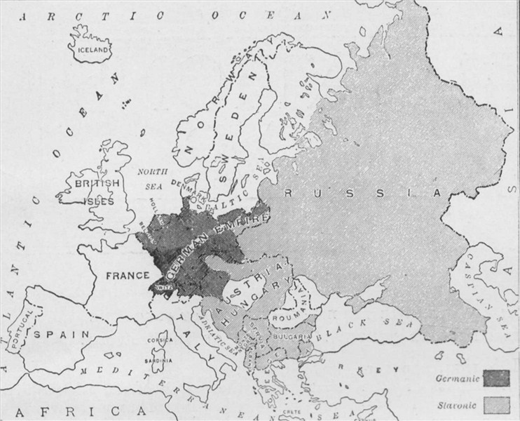 Map
of German and Slav peoples in Europe in 1914
(NW) Map
of German and Slav peoples in Europe in 1914
(NW) |
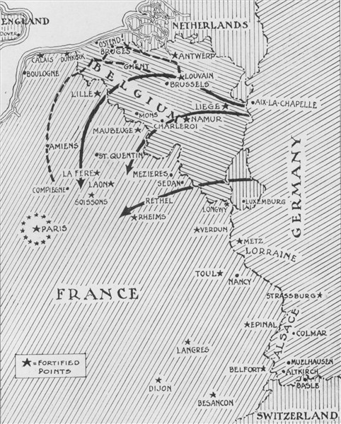 Map
of German advance to 6 September 1914
(NW) Map
of German advance to 6 September 1914
(NW) |
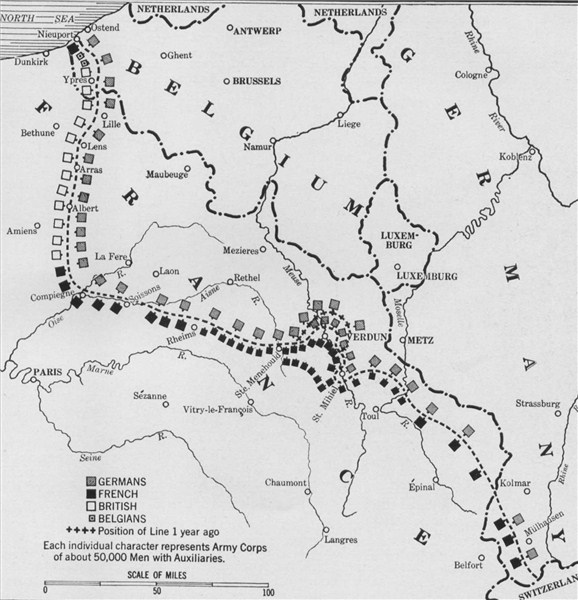 Map
of the Western Front, early summer 1916
(NW) Map
of the Western Front, early summer 1916
(NW) |
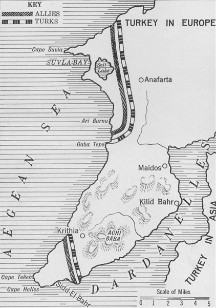 Map
of the Gallipoli peninsula
(NW) Map
of the Gallipoli peninsula
(NW) |
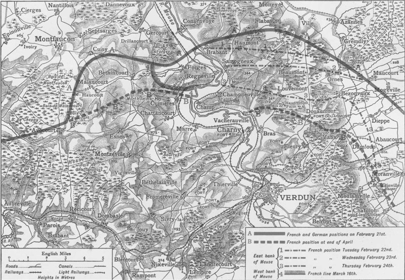
 Contemporary
map of the attack on Verdun
(NW) Contemporary
map of the attack on Verdun
(NW) |
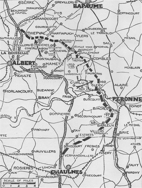 Contemporary
map of first six week's Allied progress in the Somme battle
(NW) Contemporary
map of first six week's Allied progress in the Somme battle
(NW) |
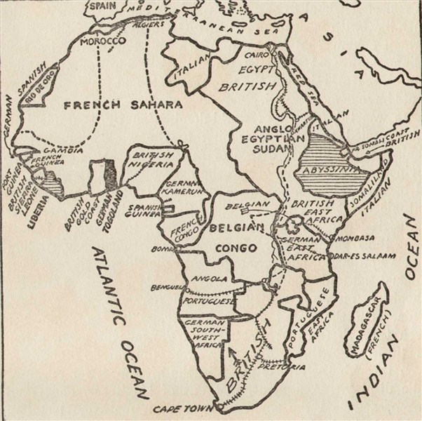
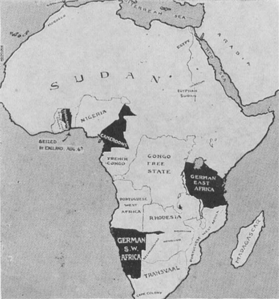 Contemporary
map detailing German possessions in Africa before the war
(NW) Contemporary
map detailing German possessions in Africa before the war
(NW) |
 Contemporary
map of the world after two years of war
(NW) Contemporary
map of the world after two years of war
(NW) |
 Map
of the Gallipoli peninsular with inset of Sari Bair region
(HW) Map
of the Gallipoli peninsular with inset of Sari Bair region
(HW) |
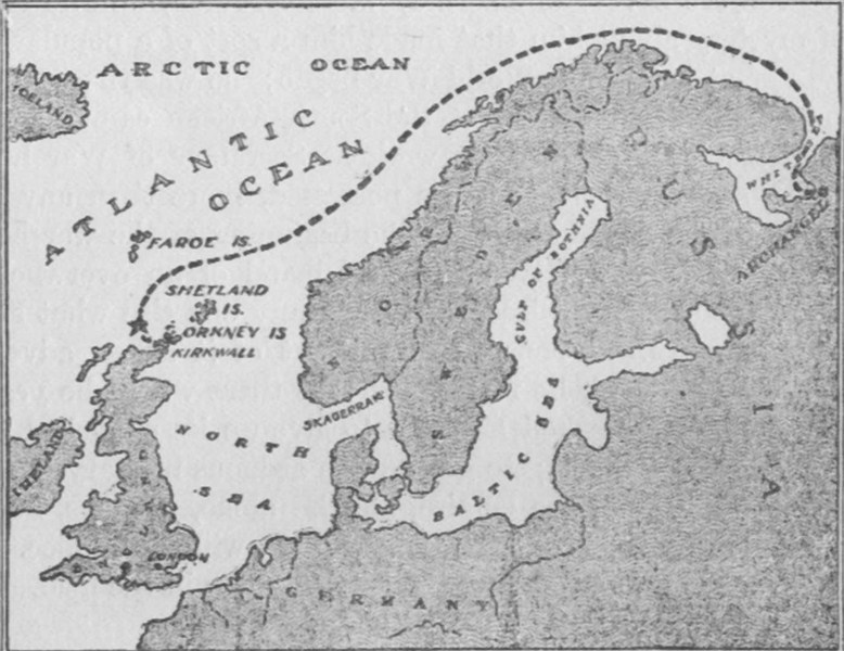
 Ports,
airfields and naval bases on the North Sea early in the war
(HW) Ports,
airfields and naval bases on the North Sea early in the war
(HW) |
 Map
of the location of Earl Kitchener's death
(HW) Map
of the location of Earl Kitchener's death
(HW) |
 Map
of the course of the Battle of Jutland, 1916
(HW) Map
of the course of the Battle of Jutland, 1916
(HW) |
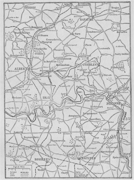 Map
of the battles fought on the Somme
(HW) Map
of the battles fought on the Somme
(HW) |
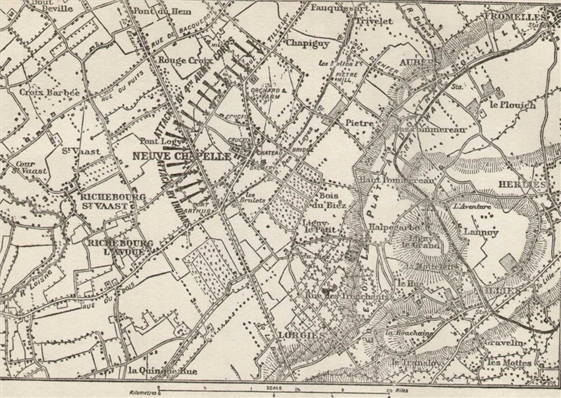 Map
of the battleground of Neuve Chapelle
(HW) Map
of the battleground of Neuve Chapelle
(HW) |
 Germany's
possessions in Africa prior to 1914
(HW) Germany's
possessions in Africa prior to 1914
(HW) |
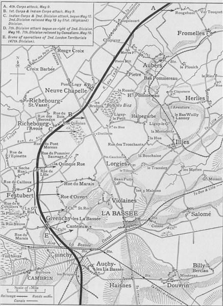
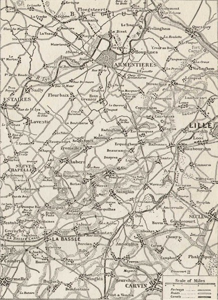 Map
of the battlefront between Armentieres and La Bassee
(HW) Map
of the battlefront between Armentieres and La Bassee
(HW) |
 English
coast towns that were raided by the Germans in 1914
(HW) English
coast towns that were raided by the Germans in 1914
(HW) |
 Territory
controlled by Turkey in 1914
(HW) Territory
controlled by Turkey in 1914
(HW) |
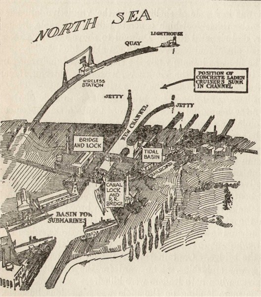 Zeebrugge
harbour blocked by the British
(HW) Zeebrugge
harbour blocked by the British
(HW) |
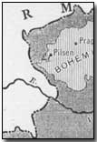
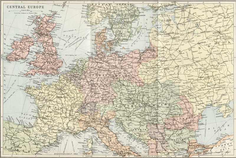 Central
Europe
(GW) Central
Europe
(GW) |
 Belgium
and Northern France
(GW) Belgium
and Northern France
(GW) |
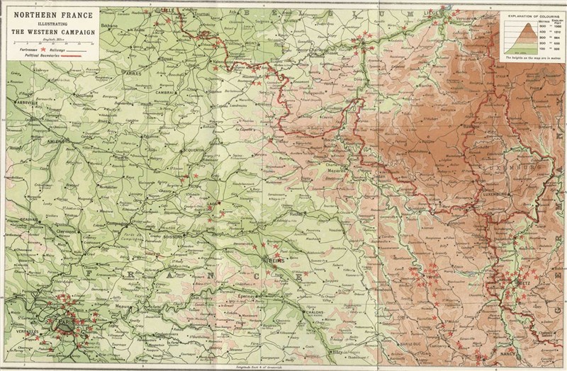 Northern
France, the Western Campaign
(GW) Northern
France, the Western Campaign
(GW) |
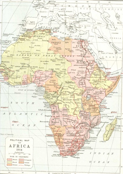 Political
map of Africa in 1914
(GW) Political
map of Africa in 1914
(GW) |
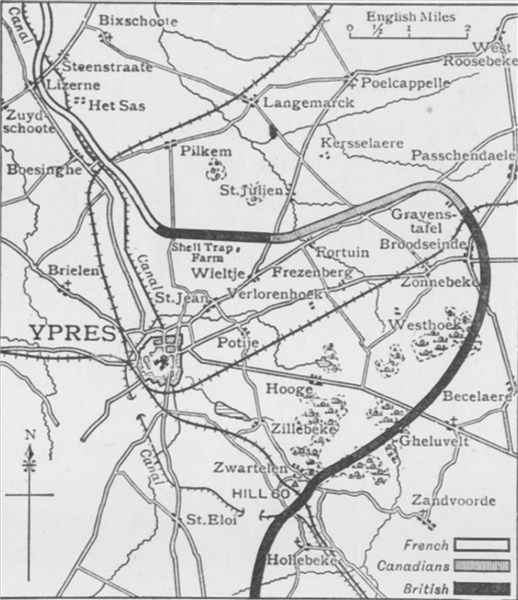
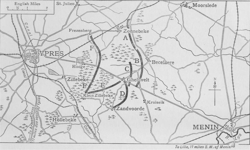 British
positions before Ypres on 29, 30, 31 October 1914
(GW) British
positions before Ypres on 29, 30, 31 October 1914
(GW) |
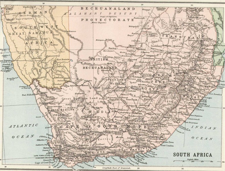 South
Africa
(GW) South
Africa
(GW) |
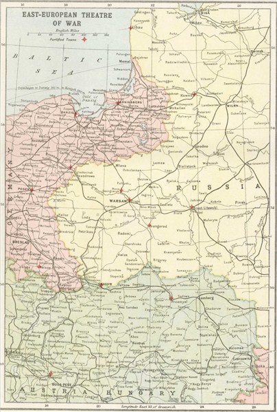 East
European theatre of war
(GW) East
European theatre of war
(GW) |
 Antwerp
and its defences, 1914
(GW) Antwerp
and its defences, 1914
(GW) |
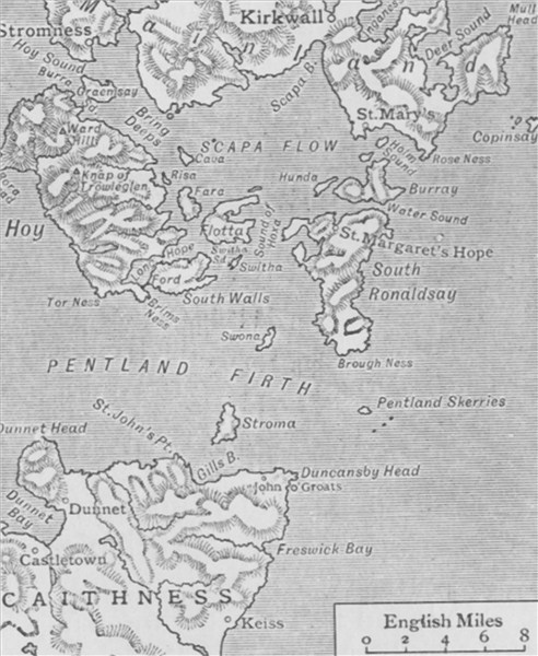 Map
of Pentland Firth and Scapa Flow
(GW) Map
of Pentland Firth and Scapa Flow
(GW) |
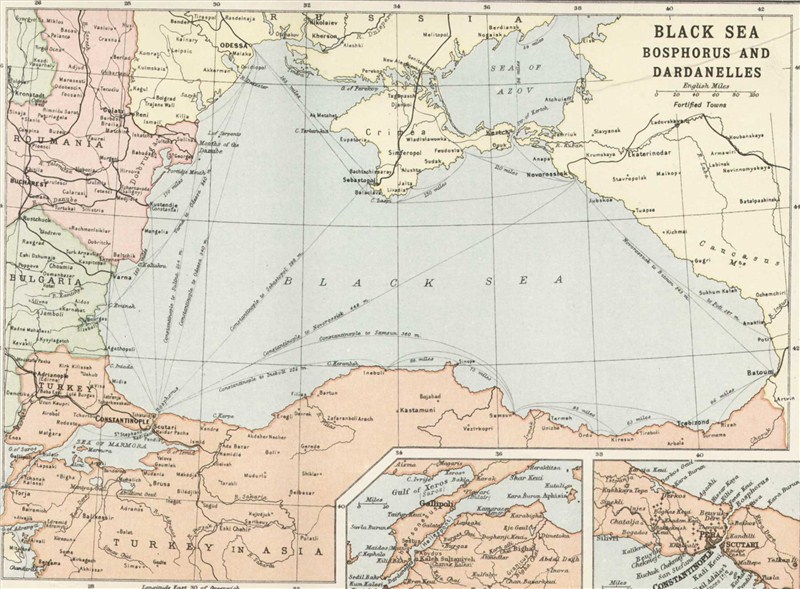 Map
of the Black Sea: Bosphorus and Dardanelles
(GW) Map
of the Black Sea: Bosphorus and Dardanelles
(GW) |
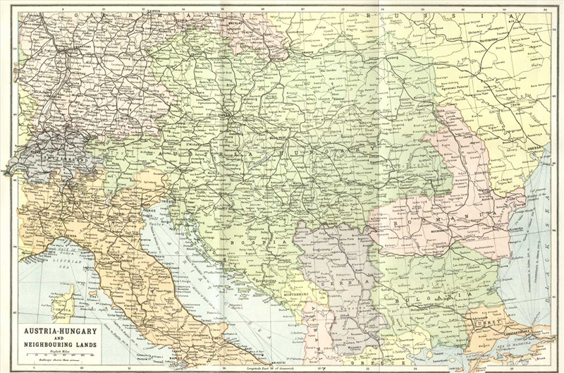 Austria-Hungary
and Neighbouring Lands
(GW) Austria-Hungary
and Neighbouring Lands
(GW) |
 North-Sea
and the Baltic
(GW) North-Sea
and the Baltic
(GW) |
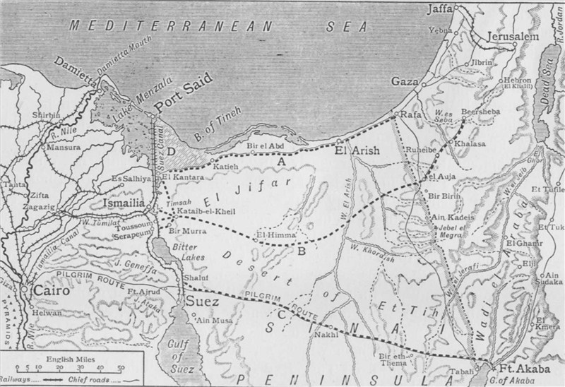 Map
of the Turkish attack on the Suez Canal, 25 Jan-3 Feb 1915
(GW) Map
of the Turkish attack on the Suez Canal, 25 Jan-3 Feb 1915
(GW) |
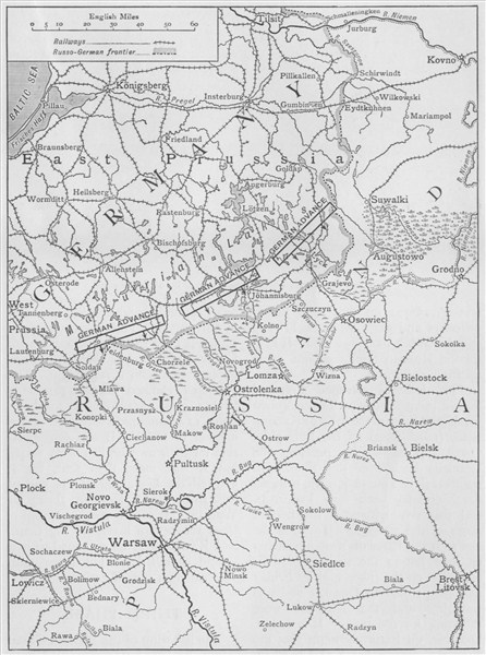 Map
of the German attack north of Warsaw, February 1915
(GW) Map
of the German attack north of Warsaw, February 1915
(GW) |
 Map
of the Battle of the Falkland Islands
(GW) Map
of the Battle of the Falkland Islands
(GW) |
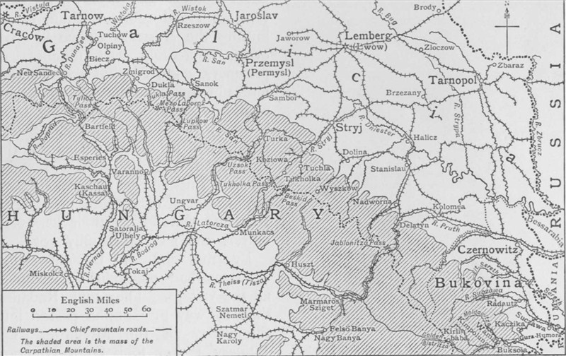 Map
of Russian positions in the Carpathians, February 1915
(GW) Map
of Russian positions in the Carpathians, February 1915
(GW) |
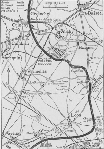
 British
and German positions at Givenchy and Cuinchy, 25 Jan 1915
(GW) British
and German positions at Givenchy and Cuinchy, 25 Jan 1915
(GW) |
 The
Polish campaign: map of the struggle from Oct-Dec 1914
(GW) The
Polish campaign: map of the struggle from Oct-Dec 1914
(GW) |
 Map
of the Cameroons
(GW) Map
of the Cameroons
(GW) |
 Sketch
map of the Cuxhaven air raid, Christmas Day 1914
(GW) Sketch
map of the Cuxhaven air raid, Christmas Day 1914
(GW) |
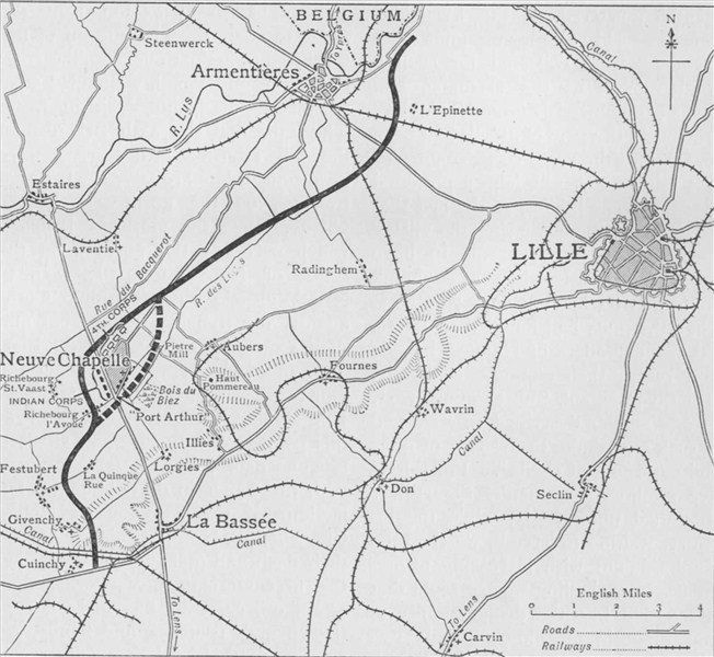 The
battleground of Neuve Chapelle, showing British positions
(GW) The
battleground of Neuve Chapelle, showing British positions
(GW) |
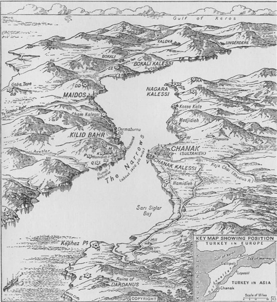 The
entrance to the Dardanelles to the Straits and the Narrows
(GW) The
entrance to the Dardanelles to the Straits and the Narrows
(GW) |
 The
Franco-German frontier
(GW) The
Franco-German frontier
(GW) |
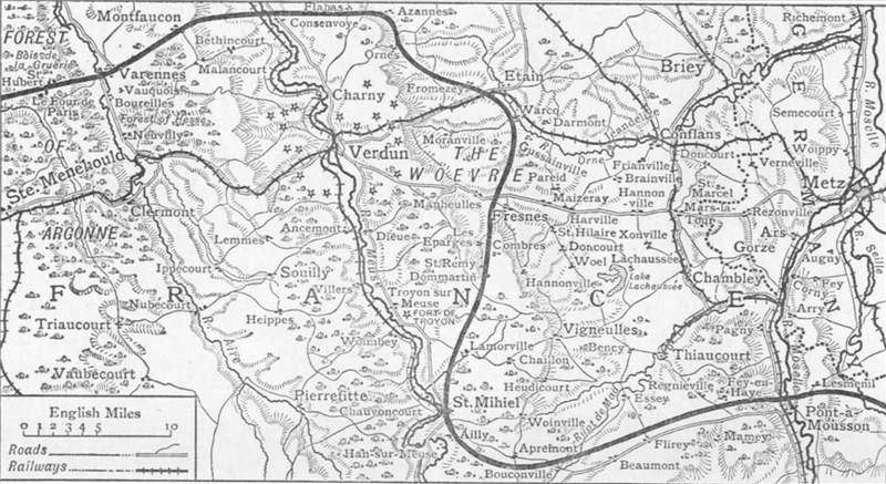 German
line around Verdun and the St Mihiel Salient, Feb 1915
(GW) German
line around Verdun and the St Mihiel Salient, Feb 1915
(GW) |
 Franco-British
lines at Ypres, February 1915
(GW) Franco-British
lines at Ypres, February 1915
(GW) |
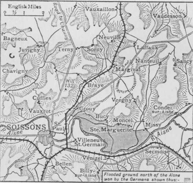 Scene
of the battle near Soissons, 11-14 January 1915
(GW) Scene
of the battle near Soissons, 11-14 January 1915
(GW) |
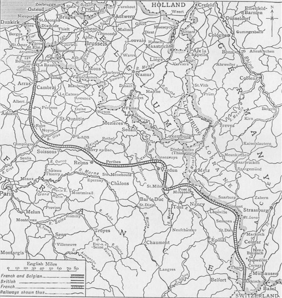 The
Allied line in France and Belgium at the start of Feb 1915
(GW) The
Allied line in France and Belgium at the start of Feb 1915
(GW) |
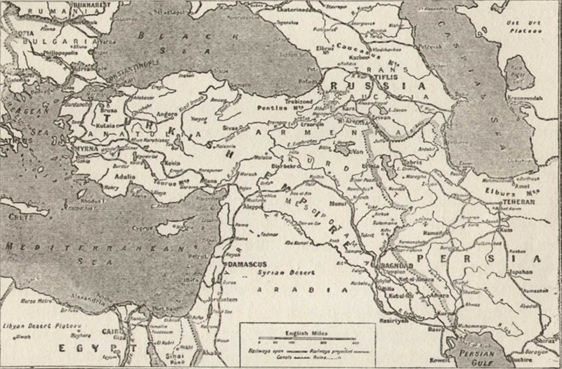
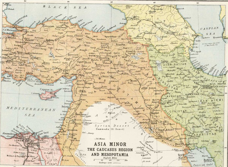 Asia
Minor, the Caucasus Region and Mesopotamia
(GW) Asia
Minor, the Caucasus Region and Mesopotamia
(GW) |
 Map
of the blockade of the German East African coast, early 1915
(GW) Map
of the blockade of the German East African coast, early 1915
(GW) |
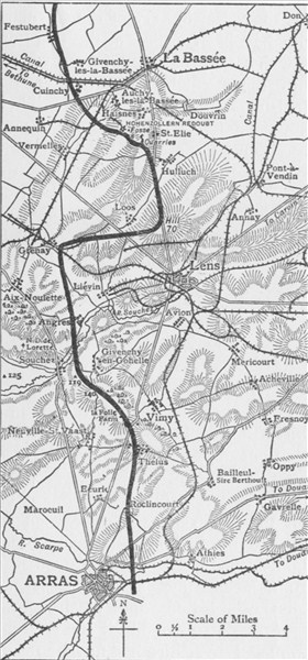
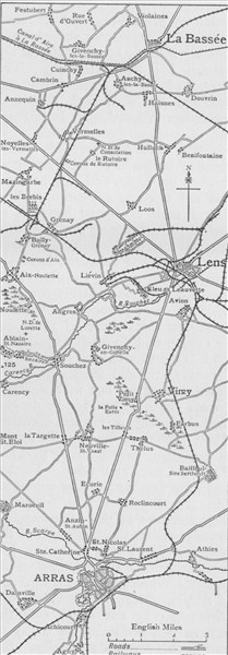 Map
illustrating French effort west of Lens, March-May 1915
(GW) Map
illustrating French effort west of Lens, March-May 1915
(GW) |
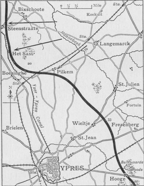
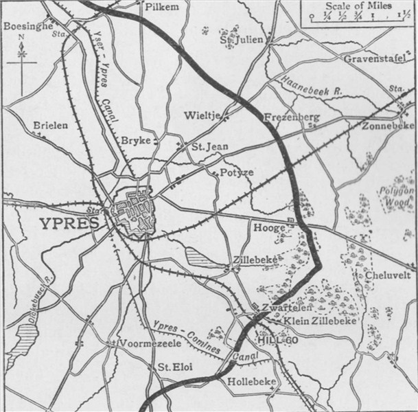
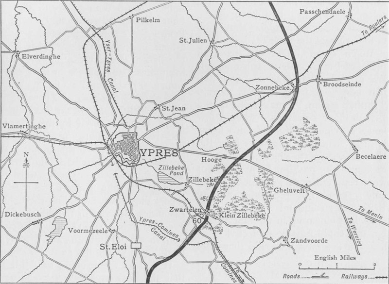 Map
of the environs of Ypres
(GW) Map
of the environs of Ypres
(GW) |
 Map
of the Ypres Salient on 25 April 1915
(GW) Map
of the Ypres Salient on 25 April 1915
(GW) |
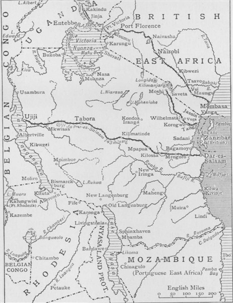
 East
Africa
(GW) East
Africa
(GW) |
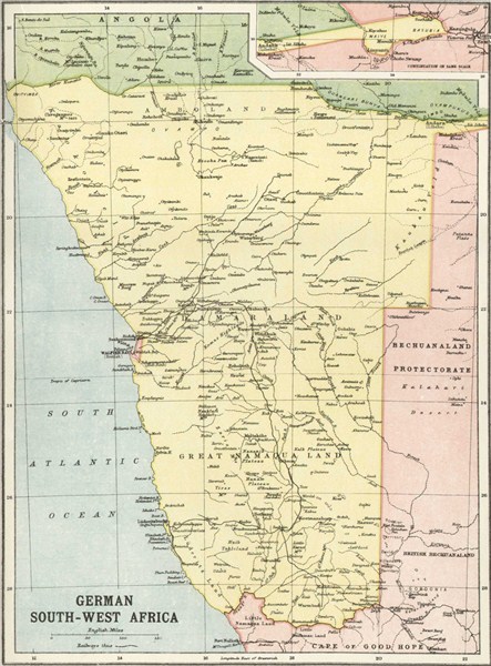 German
South-West Africa
(GW) German
South-West Africa
(GW) |
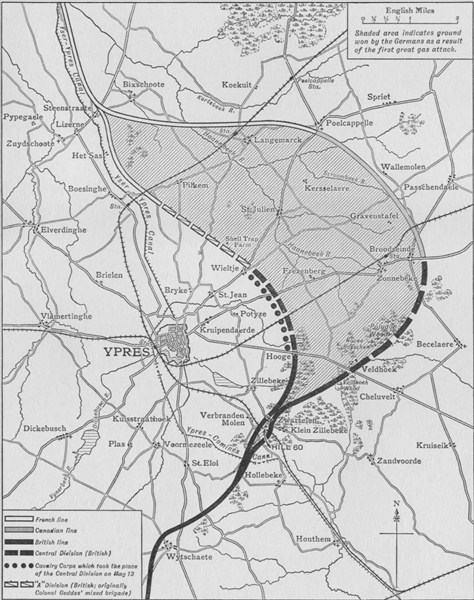
 Allied
line around Ypres during first gas attack, 22 April 1915
(GW) Allied
line around Ypres during first gas attack, 22 April 1915
(GW) |
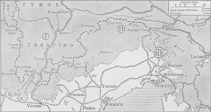 Three
theatres of war: (I) Trentino, (II) Carnic Alps, (III) Isonzo
(GW) Three
theatres of war: (I) Trentino, (II) Carnic Alps, (III) Isonzo
(GW) |
 Map
of the Allied line around Ypres, June 1915
(GW) Map
of the Allied line around Ypres, June 1915
(GW) |
 Map
of British First Army operations, May/June 1915
(GW) Map
of British First Army operations, May/June 1915
(GW) |
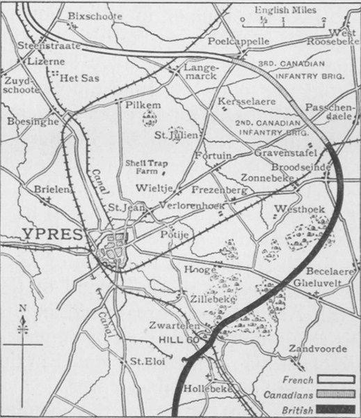
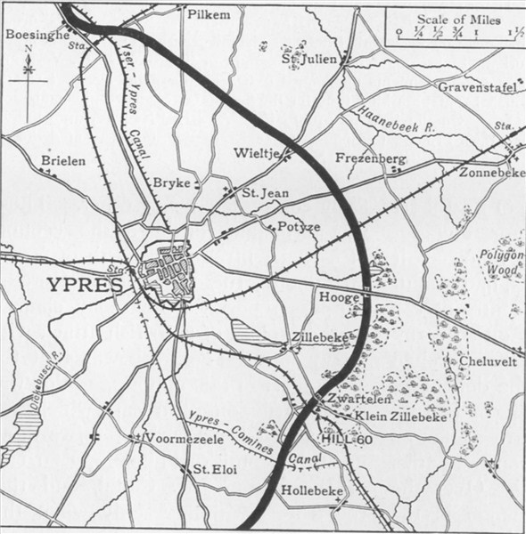
 Ypres
Salient around the Second Battle of Ypres, Apr-May 1915
(GW) Ypres
Salient around the Second Battle of Ypres, Apr-May 1915
(GW) |
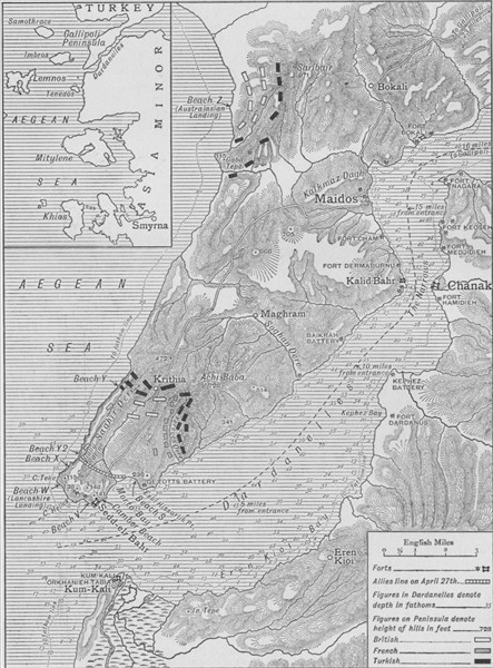 Map
of Allied operations at Gallipoli, 25 April to 30 May 1915
(GW) Map
of Allied operations at Gallipoli, 25 April to 30 May 1915
(GW) |
 Poland
1815-1914
(GW) Poland
1815-1914
(GW) |
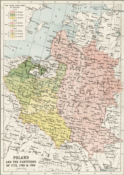 Poland
and the partitions of 1772, 1793 and 1795
(GW) Poland
and the partitions of 1772, 1793 and 1795
(GW) |
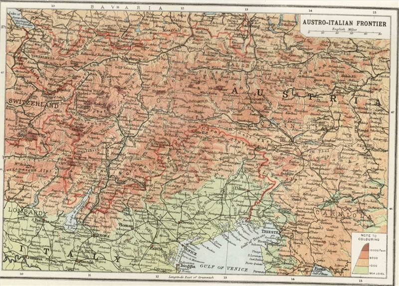 Austro-Italian
border
(GW) Austro-Italian
border
(GW) |
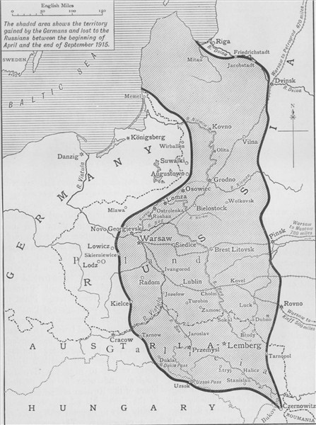 Germany's
gains from Russian territory to the end of summer 1915
(GW) Germany's
gains from Russian territory to the end of summer 1915
(GW) |
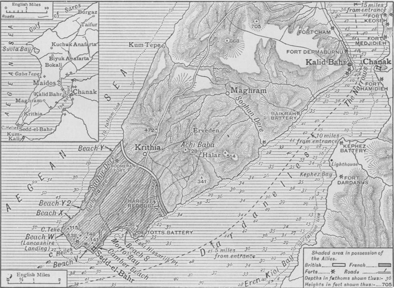 Map
showing Allied line in Southern Gallipoli, July 1915
(GW) Map
showing Allied line in Southern Gallipoli, July 1915
(GW) |
 Map
of the British salient around Ypres, summer 1915
(GW) Map
of the British salient around Ypres, summer 1915
(GW) |
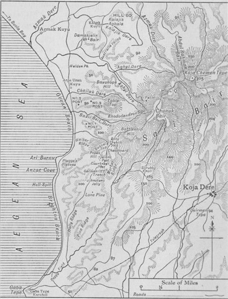 The
battlefields of Anzac
(GW) The
battlefields of Anzac
(GW) |
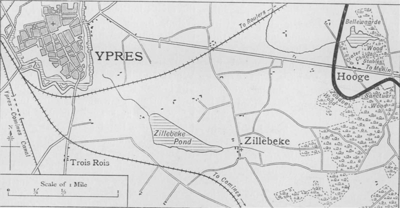 Map
showing the German salient around Hooge after 30 July 1915
(GW) Map
showing the German salient around Hooge after 30 July 1915
(GW) |
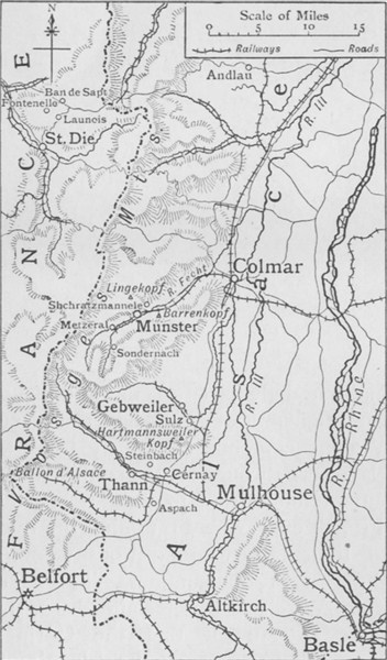 Scene
of the Summer 1915 campaign in the Vosges mountains and Alsace
(GW) Scene
of the Summer 1915 campaign in the Vosges mountains and Alsace
(GW) |
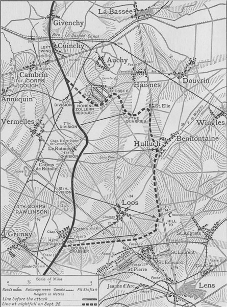 Map
of British attack around Loos, 25 Sep 1915
(GW) Map
of British attack around Loos, 25 Sep 1915
(GW) |
 Balkan
states after the wars of 1912-13
(GW) Balkan
states after the wars of 1912-13
(GW) |
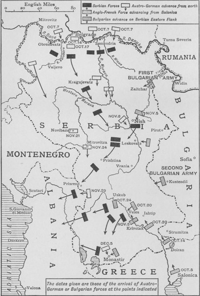 Map
illustrating the evacuation of Serbia, Oct-Dec 1915
(GW) Map
illustrating the evacuation of Serbia, Oct-Dec 1915
(GW) |
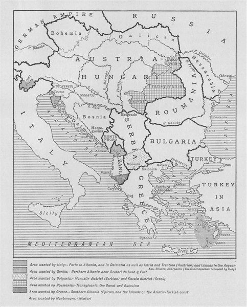 The
various war aims in the Balkans
(GW) The
various war aims in the Balkans
(GW) |
 Battle
of Ctesiphon: map of the two main Turkish positions, 22 Nov 15
(GW) Battle
of Ctesiphon: map of the two main Turkish positions, 22 Nov 15
(GW) |
 Allied
line in Artois before and after offensive of Sep 1915
(GW) Allied
line in Artois before and after offensive of Sep 1915
(GW) |
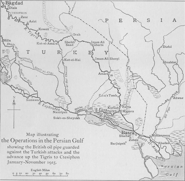 British
operations in the Persian Gulf, Jan-Nov 1915
(GW) British
operations in the Persian Gulf, Jan-Nov 1915
(GW) |
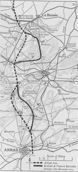
 Map
showing Allied line around Loos and Hulluch following 8 Oct 1915
(GW) Map
showing Allied line around Loos and Hulluch following 8 Oct 1915
(GW) |
 Map
of scene of German attacks east and south-east of Ypres, Feb 1916
(GW) Map
of scene of German attacks east and south-east of Ypres, Feb 1916
(GW) |
 Map
of scene of German attacks north of Ypres, February 1916
(GW) Map
of scene of German attacks north of Ypres, February 1916
(GW) |
 British
line between Ypres and Armentieres, winter 1915-16
(GW) British
line between Ypres and Armentieres, winter 1915-16
(GW) |
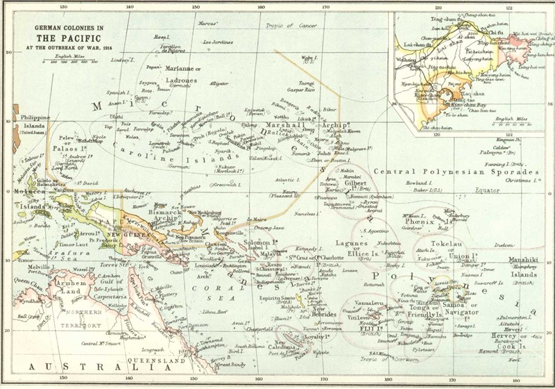 German
colonies in the Pacific at the start of the war
(GW) German
colonies in the Pacific at the start of the war
(GW) |
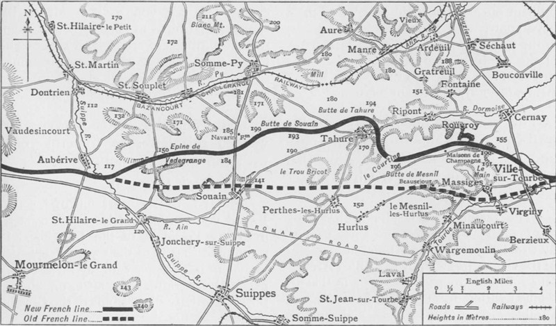 Map
showing old and new lines after French attack at Champagne, Sep 15
(GW) Map
showing old and new lines after French attack at Champagne, Sep 15
(GW) |
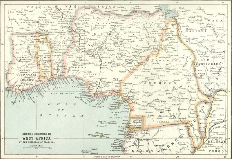 German
colonies in West Africa at the start of the war
(GW) German
colonies in West Africa at the start of the war
(GW) |
 Map
showing the area of Gallipoli evacuated in January 1916
(GW) Map
showing the area of Gallipoli evacuated in January 1916
(GW) |
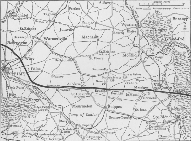 Map
of French line between Rheims and Argonne Forest prior to Sep 15
(GW) Map
of French line between Rheims and Argonne Forest prior to Sep 15
(GW) |
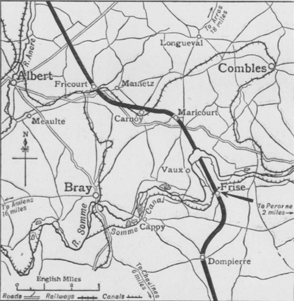 Map
showing Allied position near Albert and Frise, Feb 1916
(GW) Map
showing Allied position near Albert and Frise, Feb 1916
(GW) |
 India
and the campaigns of the Middle East
(GW) India
and the campaigns of the Middle East
(GW) |
 Map
of the opening of the German Verdun offensive, February 1916
(GW) Map
of the opening of the German Verdun offensive, February 1916
(GW) |
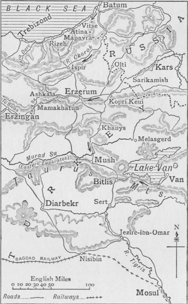 Map
showing lines of Russian advance on Erzerum, Trebizond & Bitlis
(GW) Map
showing lines of Russian advance on Erzerum, Trebizond & Bitlis
(GW) |
 Map
illustrating Anglo-French retreat from Archangel Mountain
(GW) Map
illustrating Anglo-French retreat from Archangel Mountain
(GW) |
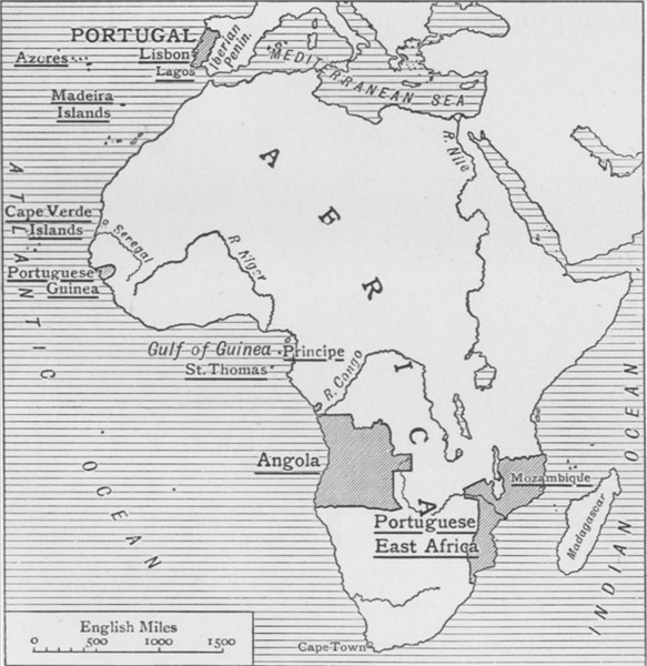 Map
showing chief harbours of Portugal and her possessions
(GW) Map
showing chief harbours of Portugal and her possessions
(GW) |
 The
Russian attack on the Deve Boyun Pass and advance on Erzerum
(GW) The
Russian attack on the Deve Boyun Pass and advance on Erzerum
(GW) |
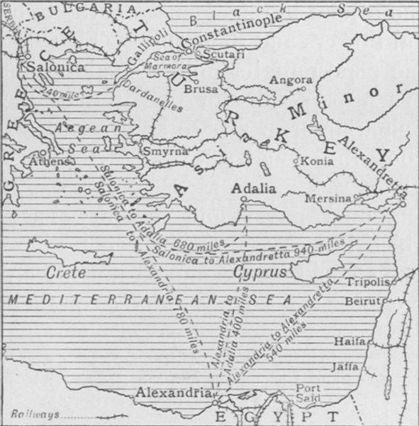 Map
illustrating the strategic importance of Salonika
(GW) Map
illustrating the strategic importance of Salonika
(GW) |
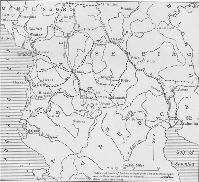 Map
showing the lines of the Serbian retreat to the Adriatic
(GW) Map
showing the lines of the Serbian retreat to the Adriatic
(GW) |
 Map
illustrating the British line in Artois, Spring 1916
(GW) Map
illustrating the British line in Artois, Spring 1916
(GW) |
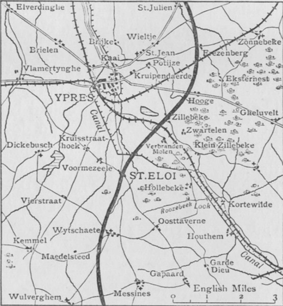
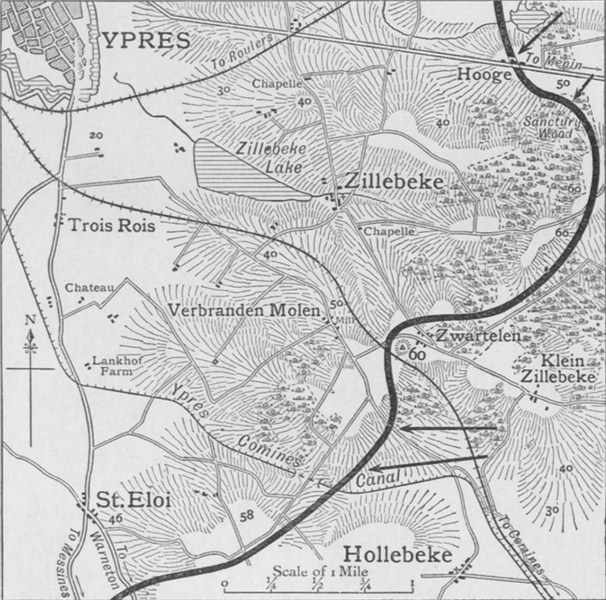
 Scene
of fighting at St. Eloi and Ypres Salient, Spring 1916
(GW) Scene
of fighting at St. Eloi and Ypres Salient, Spring 1916
(GW) |
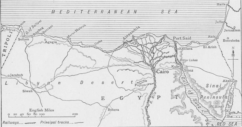 Map
illustrating the campaigns in Egypt, Feb 1915-May 1916
(GW) Map
illustrating the campaigns in Egypt, Feb 1915-May 1916
(GW) |
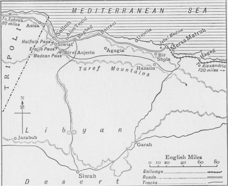 The
campaign against the Senussi on Western Frontier of Egypt
(GW) The
campaign against the Senussi on Western Frontier of Egypt
(GW) |
 Map
of the Turkish investment of Kut-el-Amara
(GW) Map
of the Turkish investment of Kut-el-Amara
(GW) |
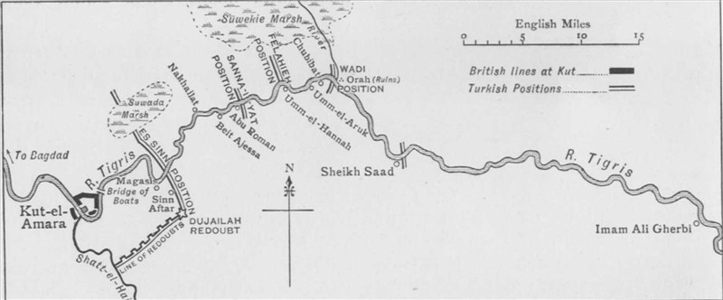 Map
of Turkish positions guarding approaches to Kut-el-Amara
(GW) Map
of Turkish positions guarding approaches to Kut-el-Amara
(GW) |
Available Pages - 1 2
The Parados was the side of a trench farthest from the enemy.
- Did you know?