Battlefield Maps - War Plans
 This section of the website reproduces large-scale maps categorised by battlefront covering the key battles and offensives fought from 1914-18.
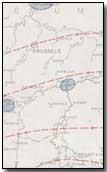
Specifically, this page contains a map showing the war plans of Germany and France.
The sidebar to the right lists each map category available within the section. Click here to view an introduction to the map series.
Three versions of each map are available - standard, large and very large. Generally standard files possess a resolution of 800x600 (approx. 70KB); large files 1600x1200 (approx. 140KB) and very large files 4000x3000 (approx. 550KB).
| Map Name | Description | Standard | Large | Very Large |
|---|---|---|---|---|
| War Plans | Schlieffen Plan and Plan XVII |
|
|
|
Click here to view a collection of maps produced within various publications while the war was still underway.
A Kite Balloon was an observation balloon controlled by a cable from the ground.
- Did you know?